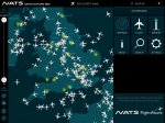
Free iPad app shows live air traffic around the world Uniquely includes real UK radar data 3D view shows the choreographed complexity of the skies Journey through the structure of UK airspace – the ‘invisible infrastructure’ A new flight tracking app by UK air traffic control company, NATS promises users a new perspective on the skies above Britain, featuring real UK radar data and a unique three dimensional view.
Most existing flight tracking apps use a crowd sourced version of a technology called ADS-B. While this is an excellent flight tracking technology, not all aircraft are equipped to support it, so coverage can be limited.
Airspace Explorer uses real radar data to track aircraft in the UK. That’s the same data that air traffic controllers use to safely guide the 6,500 aircraft that fly through the skies each day, so not only is it very accurate it also offers excellent coverage and refreshes at a fast rate.
The free app also provides a 3D view that gives a true sense of the relative altitudes of aircraft and the shape and size of the areas of controlled airspace in the UK.
12 comments
Valiantcat
11 Apr 17#1
Just downloaded this app -it's pretty good, thanks for sharing.
Siddy
11 Apr 17#2
Downloaded last night and seems ok, wonder how long till they put a 5 min delay on the app like other site till you pay or upload data. I use various aircaft tracking sites and upload data as well.
Wirral_guy
13 Apr 17#3
Air Traffic on Android does the same kind of thing (haven't got an ipad so can't compare directly).
It's quite cool working out where the planes flying overhead are going :grin:
gslgregory
14 Apr 17#4
Might have been handy including the name of the app so people can search for it. For anyone interested it's "NATS - Airspace Explorer"
paulgee31
14 Apr 17#5
They won't put in a delay, the intention was always to provide an app that educated the public about the management of airspace by NATS.
Trust me, I've spent 3 years writing this app.
mostynview
14 Apr 17#6
Thanks paulgee31 . I have paid for flightradar24 . This app is better.
Siddy
14 Apr 17#7
I have radarbox flightradar etc but this fires up so fast and the info is there ready.
jellybean1543
14 Apr 17#8
Thank you, interesting app.
lorrs58
15 Apr 17#9
Great app. Really interesting. It really is an education. Thanks op.
frunk
16 Apr 17#10
wow, fantastic app on iPad, try putting it into 3D mode over New York and moving the view to get a low viewing angle so you can also see plane altitudes, terrific visualisation.
SartoriX
20 Apr 17#11
Awesome, thanks for this
wotrulike
23 Jun 17#12
I've had this great app for a while now and still find it interesting and entertaining, very good if you or someone you know are off on their holibobs

![Fresh Breakfast Meat Box (Using code) @ Campbells Meat [Haggis / Lorne Sausage / Bacon / Black Pudding & More]](/images/topics/208684_1.jpg)


![[Xbox One] Q. u. b. e: Director's Cut on Deals with Gold](/images/topics/208716_1.jpg)


Opening post
Uniquely includes real UK radar data
3D view shows the choreographed complexity of the skies
Journey through the structure of UK airspace – the ‘invisible infrastructure’
A new flight tracking app by UK air traffic control company, NATS promises users a new perspective on the skies above Britain, featuring real UK radar data and a unique three dimensional view.
Most existing flight tracking apps use a crowd sourced version of a technology called ADS-B. While this is an excellent flight tracking technology, not all aircraft are equipped to support it, so coverage can be limited.
Airspace Explorer uses real radar data to track aircraft in the UK. That’s the same data that air traffic controllers use to safely guide the 6,500 aircraft that fly through the skies each day, so not only is it very accurate it also offers excellent coverage and refreshes at a fast rate.
The free app also provides a 3D view that gives a true sense of the relative altitudes of aircraft and the shape and size of the areas of controlled airspace in the UK.
12 comments
Air Traffic
It's quite cool working out where the planes flying overhead are going :grin:
Trust me, I've spent 3 years writing this app.